A circular walk from Swainby.
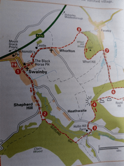
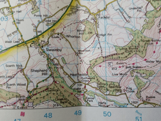
A walk taken from ‘AA 50 Walks in North Yorkshire.’ This is walk number 22. I also used the OS landranger map 93.
The walk is a mixture of road, bridleway and footpath. It goes through woodland, moor and fields. It is undulating with two steep climbs and descents. Throughout there are amazing views over moorland and it follows part of the Cleveland Way.
On the day I walked the weather was a mixture of cloud, some short showers with sunny spells. The book gives a minimum time of 3 hours, other than stopping to take a few photographs and a slight unexpected detour (I missed a footpath sign!) I managed to complete it in just under the 3 hours.
The walk starts and finishes in Swainby, North Yorkshire. A small village just off the A172 near to Stokesley and Middlesbrough. Along the way it passes near two other villages, Faceby and Whorlton. Parking is on the roadside but there are plenty of available spaces and it is free.
Swainby emerged as a village after the Black Death of the 14th Century when the villagers of nearby Whorlton left to excape the disease. It then grew with the influx of workers to the ironstone mines in Scugdale during the 19th Century as well as the jet mining on Whorl Hill. All that remains at Whorlton is the castle and church, both partly in ruin. Faceby was mainly an agricultural area and part of the Parish of Whorlton. Its name could originate from the old Norse meaning ‘Feit’s settlement.’ There is a 12th Century church, St Mary Magdeline.
When leaving the village walk with the stream on your left, along the raod towards the hills. This starts to go uphill, before it gets too steep take a path going slightly left towards Clain woods. There was tree felling, clearing parts of the wood near the path. These were clearly signed making it safe. It also helped as the path I needed could have been easily missed. This is a narrow path leading through the woods following the Cleveland Way.
Through the trees there are clear views . Along this path I met another walker, going the opposie direction, two dog walkers and two young lads running. A busy morning! The path was a little muddy, there having been a lot of rain the previous day. It was also slightly undulating, but nothing too strenuous or difficult.
You leave this path through a gate just past a bench. It goes downhill through a field. I did notice signs warning me of a bull in the field. I could see the cattle at the far end of the field, far enough away for them not to notice me. However, I did still play the game of, “Which one is the bull?” as well as checking the field for the quickest escape route when it does see me.
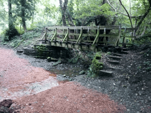
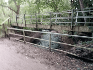
Leaving the field at the bottom corner, I came out at Scugdale Beck with two bridges going over it and joined the road. This area is sheltered and hidden in the trees, and very scenic!
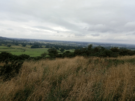
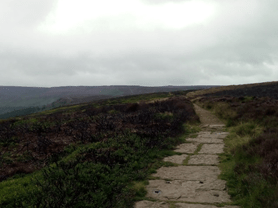
The walk follows the road past Hollin Hill farm to a ‘T’ junction at Husthwaite Green. Cross over the road back into the woods. This is the start of a long, and at times, steep climb. It is a mixture of path and steps. As it goes up there is an amazing view looking back towards Swainby and beyond, the traffic on the nearby A172 and A19 looking like toy cars.
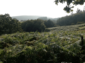
After the viewpoint it is steep walk up through the woods. Continue through a gate and up to the moor top following the path flanked by bracken. This path goes up over 300m, looking down onto the woods of Little Bonny Cliff and Great Bonny Cliff.
West Bilsdale East Bilsdale
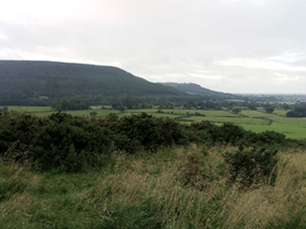
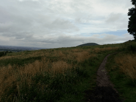
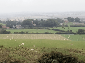
Emerging out of the woods and bracken and across the heather, past two cairns finally reaching the top there are views to the west, again back to Swainby and beyond but also to the east and Bilsdale. A chance to see the contrast between the hills and moors on the eastern side and the fields, roads and villages to the west. Along the path comes the next potential missed turn.
Looking for a small path on the left to take me down back through the heather and bracken to the edge of Little Bonny cliff woods. Luckily I found it rather more easily than I expected. Take the path down to the edge of the woods, this is much easier as you can’t go any further when you reeach the woods. Turn left at the fence and follow it, and the edge of the woods, until reaching a gate. Walking along this path as if walking to the path that took me up to the top of the moor, in a small circle. I couldn’t help wondering why I’d climbed all the way to the top to just come back down and round! It’s a walker’s thing!
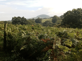
After going through the gate the path falls steeply downhill. This is a tricky descent through the trees, the path being muddy and slippy, and having to negotiate tree roots and fallen branches. Once at the bottom its throught the gate and down the wide path walking away from the woods and on towards Faceby at the bottom of Whorl Hill. Whorl Hill is easily recognisable by its dome shape, standing away from the main hills and woods. Legend has it that the hill is the home of a wyrm dragon which had toxic breath and breathed fire, regulalarly flying across and destroying the farmland and crops. The way to keep it calm and quiet was to feed it the milk of nine cows each day. It was eventually slain by a knight who was passing through Whorlton. His name was never discovered and, to this day, is known as the unknown knight!
This is the part of the walk where I made my biggest mistake, missing the footpath to take me into Whorl Wood. Thinking it was in the village of Faceby I walked straight past it, distracted by (my excuse!) a farmer cutting his hedges! After wandering round Faceby for around 15 minutes I decided to re-trace my steps back towards the woods where, as it said quite clearly in the book, I found the ‘First house on the left!’
This path leads to the next and final steep climb. It goes straight up through the woods keeping their edge on the left. It is a tricky, but short climb that heads off onto a wide path through the woods, with occasional glimpses through the trees back across the moor.
Walk through the woods unitl the path comes to a ‘T’ junction then turn left, this path going back downhill, reaching a further path and passing through a pair of gates. As you follow this path you begin to see the church and castle of Whorlton.
In the distance,Whorlton Church and castle
Whorlton Church dates back to the 12th Century. It is dedicated to the Holy Cross and was known as the Church of the Holy Rood up to the Reformation. Inside is a large oak effigy of Lord Nicholas de Meynell of Whorlton Castle who died in 1322. The church was used for the last time on 7th March 1875 although occasional services are still held there. The castle, just along from the church, was probably built by Robert de Meynell around the 12th century and was an earth and timber Motte and Bailey. By the mid 14th Century it had fallen into disrepair and was demolished, being rebuilt with a new stone tower and fortified gatehouse, this being all that remains today.
During the 19th Century large amounts of stone were removed and used to build Swainby village church.
The path continues past a farm and through fields. It was particularly tricky as a lot of nettles were beginning to stray onto the path. Wearing shorts turned it into a game of trying to avoid the nettle sting! Thankfully I got through unscathed. This is the last of the footpaths as you reach the road at Whorlton church then it is roads all the way back past the church and castle, into Swainby. Unless, like I did, take a small path on the edge of the village which takes you round the back of the cottages, past a playing area and emerges at the Black Horse pub. If you stay on the road you get to see more of the village, in particular the old school house. The buildings along Church Lane are very interesting, not least Holy Cross Church at the end of the lane.
After the walk refreshments can be taken in the Black horse pub as well as the Rusty Bike café. Swainby has easy access to the A172 and A19 making it easy to get to and get away from. All in all a very enjoyable walk covering different terrain and amazing views over wood, moor and fields. It is steeped in history especially Whorlton.
